Sys4ENCA, a semi-automatized ENCA platform

In the framework of the PAPBio programme, VITO, in collaboration with IUCN, has developed a semi-automatized platform for natural capital accounting that supports effective monitoring of natural resource and ecological footprints of human activities. This  Ecosystem Natural Capital Accounts (ENCA) platform has been tested on two protected areas in West Africa, Niokolo (Senegal and Guinea) and Bafing-Falémé (Guinea), and will now, during the next phase of this project, be rolled out on the WAP-complex (Niger, Burkina Faso and Benin).

Well-informed decision making towards sustainable growth in West Africa

West Africa, which is already feeling the devastating effect of climate change, is characterized by rapid population growth, endemic poverty and insecurity. This situation is affecting the natural capital and its ecosystem services  within the region.

Faced with these threats, the European Union, the Economic Community of West African States, the West African Economic and Monetary Union setup the Support Program for the Preservation of Biodiversity and Fragile Ecosystems, Regional Governance and Climate Change in West Africa (PAPBio), which aims to improve the management of major African natural ecosystems in order to increase resilience of both the ecosystems and the population to climate change.

Natural Capital Accounting (NCA), also known as ecosystem accounting, can provide evidence-based information for conservation and management of natural resourcesThrough the Ecosystem Natural Capital Accounting (ENCA) framework, which was set-up as a response to the requirement of the Convention on Biological Diversity (CDB) for incorporating biodiversity values into national accounting, the sustainable capacity of ecosystems to supply the services needed by humankind and assess human accountability for ecosystem degradation by inappropriate management, can be assessed.

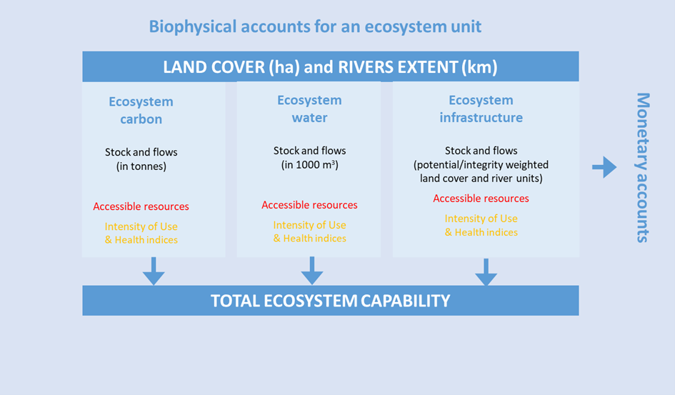
Figure 1: Schematic of the Semi-automatized Ecosystem Natural Capital Accounting (ENCA) platform

The Semi-Automatised ENCA Platform

In the framework of PAPBio, a semi-automatized Ecosystem Natural Capital Accounting (ENCA) platform has been developed (Fig. 1); it computes the yearly ecosystem value of targeted areas by combining the contribution of ecosystem carbon, water and infrastructure -based services. The results are available on the platform through maps and tables, which can be used by the stakeholders to identify critical areas (hotspots) and assess ecosystem degradation and improvement, as well as the potential causes of changes.

An initial platform evaluation, in collaboration with local expersts, has been performed on two zones located in the Fouta Djallon highlands in West-Africa (Fig.2). A multi-level approach has been used to assess the capacity of the platform as an integrated and efficient tool to support decision makers in the context of ecosystem accounting. The three level are:

  • Tier-1 level, which is a contextual level where country accounts for Sénégal and République de Guinée are computed based on global publicly available datasets,
  • Tier-2 level, which focusses on the accounting of two large transborder ecological areas within both countries, Niokolo (Sénégal) and Bafing Falémé (République de Guinée), based on national datasets,
  • Tier-3 level, which focusses on the Parc National du Moyen Bafing within Bafing Falémé, using local datasets, collected by the Wild Chimpanzee Foundation.
Figure 2: Geographical location of the two transborder ecological areas; Niokolo and Bafing Falémé.

Platform evaluation on a transboundary area between Senegal and Guinea

The ecosystem accounting of the Niokolo and Bafing Falémé transborder areas (Figure 3) confirms the high ecological value (~3) of these areas. The nature protection status and the low fragmentation seem to be important drivers of their ecological integrity (orange in the bar-chart of Fig.3). The ecological value of the corridor between both areas (‘corridor’ in Fig. 3), on the other hand, is significantly lower. A strengthening of the landscape management plan will be required, as this corridor is expected to develop into a functional zone of passage for fauna.

Important differences in ecological values are also observed within the protected areas. The center of the Bafing Falémé  Paysage shows a value far above average. It is characterised by high biodiversity and has recently been recognized as national park, the ‘Parc Naturel du Moyen-Bafing’ (PNMB). The park however faces important threats; urbanisation, farming and ranching, a prospective dam construction (Koukoutamba), hunting, wood harvesting and bush-fires. It is therefore crucial to keep monitoring this park to preserve its ecological value. In the eastern part of the Bafing Falémé, a hotspot of low ecological value (‘hotspot 1’ in Fig.3) was identified. Despite the fact that this section is targeted to rehabilitate three community forests (Fig.2), it is characterized by high human activity; i.e. intensive agriculture and mining. Here, significant changes in management practices will be required.

Concerning Niokolo, the ecological value (‘hotspot 2’ in Fig.3) is significantly lower in the southern part, located in Guinea, compared to the north part, located in Senegal. Difference in management practices between both countries explains this. On the Guinean side, conservation activities are solely in practice in the core area of the Badiar Biosphere Reserve; on the periphery, a co-management system is in place to allow the various communities to use the site for agriculture and wood supply.

Figure 3: Ecological value of the Niokolo and Bafing Falémé transboundary areas, as computed with ENCA for the year 2000.

Pressure on the Paysage induces degradation

Over the 2000-2018 period, the ecological value of the western and central part of the Bafing-Falémé Paysage has gradually increased (in green in Fig. 4) while in the far east,  it has significantly decreased (orange area highlighted as ‘hotspot’ in Fig. 4). As mentioned earlier, this area is subject to intensive agriculture and mining practices. An increase of these activities might be the underlying cause of this rapid degradation. The same trend can be observed outside the the boundaries of the Paysage. To counteract the impact of increased pressure on land from neighbouring villages, good governance and adaptations of the practices will be required. 

Figure 4 also reveals a zone of degradation within the Natural Park of the Moyen-Bafing. This could be connected to preparatory work for the new hydro-electricity dam (Koukoutamba) in the southern part of the park. As the Bafing river flows north, this dam will probably have an impact on the entire park and all upstream areas. Future scenarios on development could help to assess the evolution of the ecosystem value and to anticipate the required management to avoid further degradation.

Figure 4: Trend between 2000 and 2018 of the ecological value of Bafing Falémé transboundary area, as computed with ENCA

Outcomes of the first phase of this project

We may conclude that the ENCA tool provides a well-structured basis for monitoring and evaluating current and prospective programs and governance practices. The relevancy of the results, however, depends largely on input data, methodology, functionality as well as on the interpretation of the results. The evaluation of these elements is therefore capital and has to be in collaboration with local experts. COVID-19 has however significantly impeded this process as physical meetings could barely take during the project. The results of such an evaluation will further lead to an improvement of the tool and its use. 

For more information on the work of VITO on Natural Capital Accounting, please visit the following website: https://remotesensing.vito.be/case/natural-capital-accounting.